

The Earth’s surface is constantly changing, and until now, it’s been impossible to map out these changes as accurately as possible and in «near real-time». Google’s Dynamic World app plans to change this by providing recent data and the ability to track changes to the land using AI.
Dynamic World also provides more detailed data than ever before. Here’s everything you need to know about Dynamic World.
Google Debuts Dynamic World App to Track Earth’s Surface Changes
Google has launched Dynamic World, an application that provides detailed data on how the Earth’s surface is changing due to various activities. The company developed Dynamic World in partnership with the global nonprofit organization World Resources Institute (WRI).
Dynamic World tracks land cover changes due to environmental changes, like floods and snowstorms, and changes induced by human activity like urban development and deforestation. According to Google, Dynamic World aims to avail data that has historically been tough to get.
«Historically, it’s been difficult to access detailed, up-to-date land cover data which documents how much of a region is covered with different land and water types,» Google’s Senior Program Manager for Google Earth Outreach, Tanya Birch, wrote in a blog post.
How Google’s Dynamic World App Works
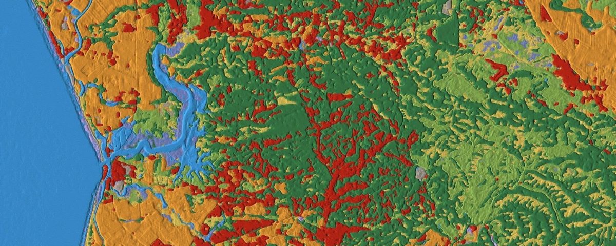
Under the hood, Dynamic World runs on Google’s Earth Engine and AI Platform. Dynamic World provides the most recent data on the Earth’s land cover—as recent as two days ago. The data is more detailed with a 32 feet resolution, allowing you to see what sits on a particular piece of land and how it is being used.
With such precision and near real-time data, Dynamic World will enable researchers and policymakers to view different land cover types in a given region with more accuracy.
For example, you can see how much of a region is covered by land and water types. According to Google, most current datasets only focus on the major land or water cover type visible from a satellite image. Of course, such doesn’t give an accurate picture of how dynamic the Earth’s surface is. Here’s an in-depth look at how satellite imaging works.
Dynamic World goes a mile further, leveraging AI and cloud computing «to detect combinations of different land cover types and make conclusions about how likely it is for each of the nine types to be present in every pixel (about 1,100 square feet of land) of a satellite image,» according to Google.
The major land cover types included in Dynamic World are grass, water, built-up areas, trees, crops, bare ground, flooded vegetation, shrub/scrub, and snow/ice.
You can see from the screenshot below how the land cover in Boston, MA, changed from a mixture of land cover types to snow following the mid-2021 snowstorm experienced in the region captured in Google’s Dynamic World app.

To ensure up-to-date data on land cover, Google’s AI model produces over 5,000 Dynamic World images per day. This ensures that Dynamic World can map out the global land cover faster, in two to five days (depending on location), relative to traditional global land cover maps that typically take months to produce.
The only limitation with Dynamic World is, as, at launch, you can only view land cover data dating back to June 2015. You can head over to Dynamic World to check out the app. Or, if you’d like to see the power of AI a little lightheartedly, there are plenty of fun AI tools you can check out.
Why Data from Dynamic World Is Important
Google’s Dynamic World app data is vital to researchers and policymakers in understanding land cover and making more informed decisions.
First, both can use this data to help plan for protecting our planet in the future, especially with rising concerns on climate change globally. They can understand how the land is being used, which can help protect critical areas from being destroyed by human activity or restore destroyed land.
Both parties can also detect and quantify significant changes to land cover due to natural calamities like volcanic eruptions and wildfires as soon as possible. Dynamic World can also alert them know when unforeseen changes to land are taking place within their jurisdiction. Researchers will also be able to use Google’s machine learning model to build their maps.
Immerse Yourself in Detailed Maps From Google
Dynamic World provides more recent data than other maps, thanks to the two-to-five day update frequency. If you’re more concerned about the world a little closer to home, Google Maps has a feature that lets you immerse yourself in a location.
